How to collect data
In our experience, the following data collection framework allows school infrastructure managers to obtain information on the structural, architectural and functional conditions of large school portfolios in a systematic and sustainable way. On the Toolkit section, you will find tools and guidance to facilitate data collection using the GLOSI framework. Those tools were developed to assist in the desktop processing of collected data and creation of an exposure database for quantitative risk assessments following the GLOSI taxonomy.
The figure below illustrates the overall GLOSI data collection framework. It includes three Tiers, or data collection levels, with increasing levels of technical detail. Typically, Tier 1 and Tier 2 are required to build and update a baseline of school infrastructure for risk assessments, or to conduct a post-disaster damage assessment. Tier 3, on the other hand, would generally be required when the index buildings identified in a specific case are not included in the GLOSI Catalog of Building Types, or when some specificities of those index buildings require detailed fragility/vulnerability assessments.
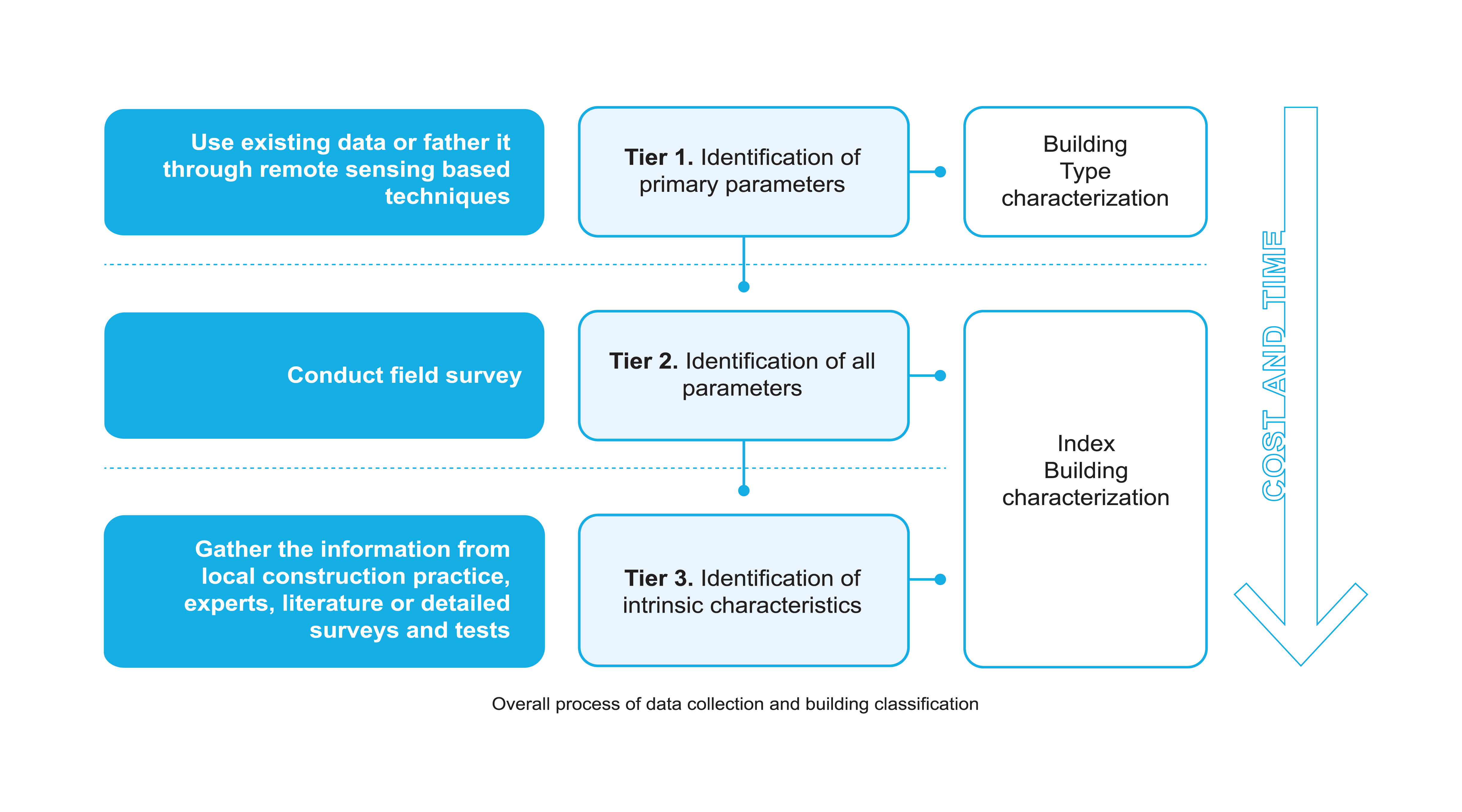
- Tier 1: the objective of Tier 1 is to identify different building types based on three main taxonomy parameters, including main structural system, height range, and seismic design level. This Tier can be based on analysis of existing database, if the database has sufficient information. Otherwise, it can be conducted through photographs collected by non-technical persons or rapid visual survey. Note that the analysis of these information should be carried out by experienced seismic/structural engineers.
- Tier 2: the objective of Tier 2 is to define a complete taxonomy string and then characterize a specific index building. As a result, more detailed structural and geometric information is required. This Tier is mainly based on field observation and measurements, which needs to be performed by civil engineers with adequate trainings. Moreover, experienced seismic/structural engineers are required for the evaluation of taxonomy parameters and classification of index buildings.
- Tier 3: the objective of Tier 3 is to collect all the detailed information to perform a reliable fragility/vulnerability assessment for specific cases. This Tier includes the collection of the intrinsic characteristics of building types, which specifically refers to geometric dimensions, mechanical properties of material and structural details. Detailed assessments are usually required, such as destructive tests to know the internal reinforcement details or non-destructive tests to establish material properties. Also, detailed analysis using numerical models are often necessary.
Toolkit
The data collection tools developed under GLoSI follow the objectives listed below:
- Ensure a consistent and standardized data collection – the tools are designed with flexible formats and are applicable to a wide range of building types.
- Avoid implicit biases of the surveyor - the tools record observable quantities, rather than the information requiring judgment and interpretation.
- Require limited time on site - the tools are concise and easy to use.
The data collection tools under GLoSI can be specifically targeting pre- or post-disaster condition. Depending on the level of details needed for difference analysis objectives, basic and advanced data collection forms are developed specifically for school buildings under GLoSI. To ensure the efficiency of data collection and the consistency of the data collected, these forms are designed to be standardized, simple to use, self-explanatory, and globally applicable. In addition, to facilitate the data collection process on site, mobile applications of these forms for both android and IOS devices are provided for users to download. Note that these forms are designed to be mainly based on engineering observations and measurements, which should be used by civil engineers with adequate trainings. To classify building types or characterize index buildings, the further evaluation and analysis of the data collected should be performed by experienced seismic/structural engineers. To download the App please contact the gpss@worldbank.org.
Manual
For the data collection tools developed under GLOSI, manuals are provided here to:
- Help users understand the functions, capabilities, and limitations of different tools, thereby select the suitable tools for specific purpose of the data collection activities.
- Prepare users with a detailed step-by-step instruction on how to use the data collection tools.
- Ensure the consistency and quality of the data collected using these tools, with examples on various scenarios for different building types to guide the users to record their observations and measurements with the least implicit bias possible.
These manuals can be used for the training of civil engineers who will conduct the data collection activities, or to inform the experienced seismic/structural engineers who will evaluate/analyze the data collected using these tools.